
May 25 - Stocks were mixed on Wall Street as debt ceiling talks drag on, while an exit from Treasuries suggests that investor nerves are rising. The VIX is trading just below 20 at midday, while the dollar index is trading near 104.2. Yields on 10-year Treasuries are trading near 3.78%, while yields on 2-year Treasuries are trading near 4.46%. Crude oil prices are 4% lower as fund managers increase their short positions ahead of the OPEC+ meeting. Grain and oilseed prices are mixed, with prices consolidating ahead of the three-day holiday weekend, with wheat prices modestly higher, and corn and soybeans mostly soft. Yet, the path of least resistance is generally weaker.
Export sales of old-crop corn were a net negative 3.0 million bushels in the week ending May 18, including net reductions for China of previous purchases of 13.1 million bushels, while new-crop sales were a net 2.1 million. Soybean export sales totaled 4.2 million old-crop and 0.04 million new-crop bushels. Wheat export sales during the week were a net negative 1.7 million old- and plus 9.0 million new-crop bushels. The one positive in this morning's report was sales of 341.3K metric tons of soymeal. Marketing year to date corn export sales fall short of the seasonal pace needed to hit USDA's target by 132 million bushels, while soybean sales fall short by 100 million.
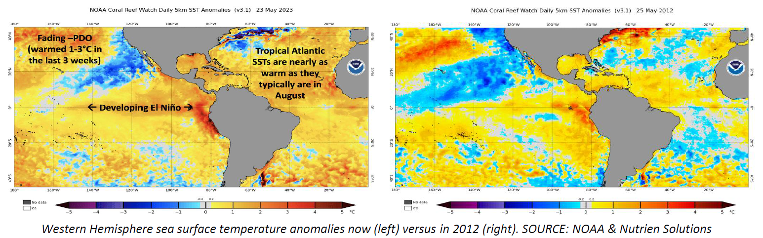
Sea surface temperature anomalies are rapidly warming in a couple key areas of both the Pacific and the Atlantic, as shown in the graphic below. First, sea surface temperatures are rapidly warming in the equatorial Pacific, pushing us into an El Nino weather pattern at a rapid pace. Only two other years in modern history have seen such a rapid transition from a strong La Nina to an El Nino pattern - 1997 & 2009 - with models now projecting a strong El Nino by the end of the growing season. Second, sea surface temperature anomalies are rapidly warming in the northern Eastern Pacific along the West Coast of Canada and the United States as well. The cool waters currently there give us a negative PDO - Pacific Decadal Oscillation index. A negative PDO typically favors a hot dry high pressure somewhere over the Midwest in the summer, but this -PDO is moderating rapidly as it normally does in an El Nino, and as the models had projected. That process could still stall, which is a risk worth watching, but thus far the trend is in the right direction. The other place where we're seeing warming is in the northern Atlantic, where water temperatures are already at levels normally seen in August. Now compare the above to where sea surface temperature anomalies were at this same time in 2012 on the right. It's a much different picture. The El Nino development was so slow that it failed to negate the -PDO, combined with a relatively cool Atlantic. The one thing that has not yet been established is the location of this year's Bermuda High, which could prove to be a significant factor in determining rainfall in key U.S. growing areas.
Forecasters continue to think that the current Midwest weather pattern will begin the typical El Nino shift toward increased Midwest thunderstorm activity around the second week of June, but stress is likely to build between now and then. Commodity Weather Group notes that crop-weighted Corn Belt rainfall since April 1 is on pace to end up around the second or third driest for the period since 1979. It looked at all of the dry starts over the years, and yes, 1988 and 2012 were included. Yet it found that many other years ended up being wet for the summer, with even above-trend yields. That doesn't necessarily say how this year will end up, but it does say that a dry start doesn't predetermine the rest of the summer. As I pointed out yesterday, transitional El Nino summers tend to start dry before thunderstorm activity picks up in the last half of June.