
Harvest and Soil: Moisture Trends and Agricultural Planning*
The period of highest moisture in Brazil’s North, Center-West, and Southeast regions—characterized by intense cloudiness, convective rainfall, and moisture circulation—is coming to an end. In this context, systems such as the South Atlantic Convergence Zone (SACZ) and the Intertropical Convergence Zone (ITCZ) are losing direct influence over these areas. In this report, we analyze surface moisture levels at the end of May, compare them with previous months, assess the dynamics of this variable throughout the month, and present soil moisture forecasts for the upcoming days in June.
Monthly NDMI Analysis
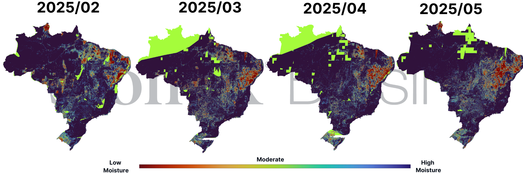
The NDMI (Normalized Difference Moisture Index) is an indicator that reflects changes in soil moisture caused by rainfall, evapotranspiration, and vegetation development.
At the end of April, there was a noticeable reduction in yellow to reddish patches (indicating low moisture) in the Center-West, Southeast, and Tocantins regions compared to March. However, by the end of May, these patches returned and intensified, indicating a drop in soil moisture.
This can be observed in the NDMI monitoring, both in the expansion of affected areas (previously blue regions turning yellowish and greenish) and in the severity of the drought (more intense red spots) and the emergence of new areas with greenish tones—an alert sign, considering the dry season hasn't officially started yet.
Key affected regions include: the northwest of Minas Gerais and the Triângulo Mineiro, the outer areas of Goiás (particularly the northeast), eastern Mato Grosso, Tocantins (bordering the MATOPIBA region), the north and east of Mato Grosso do Sul, and most of São Paulo state (except the coast).
NDMI Index – February to May 2025
Sources: Copernicus prepared by StoneX
NDMI Dynamics in May and Rainfall Irregularities
Although total rainfall was above average in several parts of the North, Northeast, and Center-West, its distribution was highly irregular. Key observations include:
Heavy rains concentrated in just a few days;
- Over 20 consecutive days without significant rain in states like Minas Gerais, Goiás, and Tocantins (as detailed in the previous weekly report).
- Although the total rainfall during the transition months is a positive signal, the concentration in a few, likely intense, events is not ideal for proper soil water recharge.
Poor rainfall distribution can lead to rapid saturation of the upper soil layers, especially those with larger pores. When this happens, rainwater struggles to infiltrate deeper into the soil and ends up running off over the surface toward rivers and streams.
This effect is even more common in agricultural areas, where soil is usually compacted due to heavy machinery use. With less pore space, water infiltration becomes more difficult.
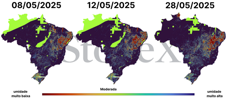
These conditions help explain the deterioration of NDMI values in regions like eastern Mato Grosso, Goiás, and northwestern Minas Gerais. Another contributing factor is the above-average temperatures recorded in recent months, which intensified water loss through evapotranspiration—the combined evaporation from the soil and transpiration by plants.
Dynamics of the NDMI Index for the Month of May
Sources: Copernicus prepared by StoneX
Soil Moisture in June: Cold Fronts Benefit the Center-South, While Drought Expands in the Northeast
The forecast for the topsoil moisture layer, which includes the first 7 to 10 centimeters, is generally positive when compared to previous years. Soil moisture at this level is crucial for successful harvests, directly influencing the quality, yield, and ideal timing of harvesting crops like second-season corn (safrinha), coffee, and sugarcane.*.
Soil moisture forecast for June 11–21, 2025, with daily maps: 11 (A), 12 (B), 13 (C), 14 (D), 15 (E), 16 (F), 17 (G), 18 (H), 19 (I), 20 (J), and 21 (K). Interpretation considers the topsoil layer and the following categories: Dry: dry soil. PWP (Permanent Wilting Point): water unavailable to plants. CAP (Field Capacity): optimal water retention. Sat: saturated soil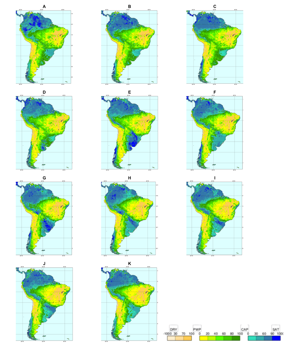
Sources:ECMWF
In early June, a moderately strong cold front transported moisture across much of the Center-South of Brazil. The most benefited areas were Mato Grosso do Sul, southern Mato Grosso, and all of the Southern Region (except Rio Grande do Sul). Additionally, rainfall was recorded along the far eastern coastline of the Northeast, associated with humid trade winds from the ocean.
Forecast maps show a wide range of soil moisture conditions across the country. In some areas, the soil is nearing the wilting point (PWP)—when water is no longer available to plants—represented by yellow and brown tones. In others, the soil has reached field capacity (CAP) or even saturation, shown in green to bluish tones, indicating good or excessive water availability.
In western Brazil and peripheral regions, the soil shows intermediate moisture conditions (green-yellow tones), which support both harvesting activities and the transition into the dry season.
However, in the interior of the Northeast, there are already consistent signs of dry soil, with brown patches visible on the maps. These drier conditions are expected to expand further, possibly advancing into parts of the Southeast, as the dry days continue.
In the South, persistently high soil moisture levels reflect the continued influence of cold fronts. While beneficial for vegetation, excess moisture may delay grain drying and harvesting operations. Additionally, waterlogged soils increase the risk of plant diseases, requiring close attention to phytosanitary management.
In particular, Paraná and southern São Paulo should closely monitor soil conditions in the coming weeks to ensure effective harvest planning and mitigate potential losses related to excess moisture and disease pressure.
*When the topsoil layer is well hydrated, it becomes more manageable, reducing machinery effort and preventing soil compaction losses. Additionally, good moisture conditions at this final crop stage support plant health and help conserve the soil. This layer is also the most exposed to the environment, responding rapidly to sunlight, wind, and rain.