

- A consolidated La Niña for the OND quarter characterized by increased cloudiness, intensity and concentration of precipitation for most of Brazil, with possible winter events in December and January.
- Precipitation will increase in volume over the course of the month and will probably become more frequent and widespread towards the end of this month and the beginning of November.
- Maximum temperatures will begin to fall in the middle of the month due to increased cloudiness in the Southeast, Goiás and the Cerrado of Minas Gerais.
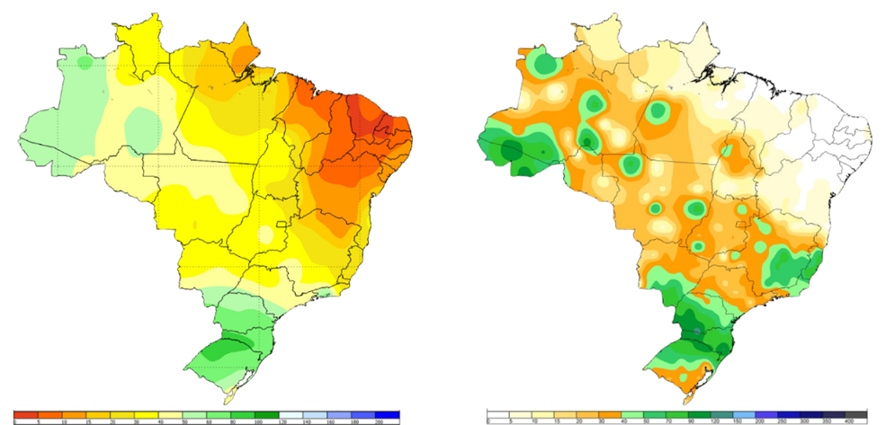
Accumulated rainfall: A) Brazil's 1991-2020 climatological normals for the first decade (mm) for the month of October and B) accumulated over the last 10 days map drawn up on October 13, 2024.
Source: Inmet
The rainy season has begun, and moisture corridors formed in the first 10 days of October. Precipitation (PPT) was above average in the state of Acre and in the eastern Amazon region. In the North, rainfall accumulated over 70 mm; normally in these places the accumulated PPT in 10 days ranges between 50 and 60 mm. In the majority of the state of Rondônia, the PPT accumulated over the first few days was lower, oscillating between 15 and 30 mm, compared to the normal, which is over 40 mm.
In Mato Grosso and Goiás, localized accumulated PPT of 40 to 70 mm was recorded, but overall, for the state as a whole, rainfall was lower (20-30 mm) than expected, which is normally more than 30 mm. In Mato Grosso do Sul and Minas Gerais, the accumulated rainfall was concentrated in the south and southeast of each state, respectively, while the volumes in the north were below normal.
The states of São Paulo and Paraná recorded heavy rainfall, ranging from 40 to 120 mm. The same was observed in the state of Espírito Santo. In the Northeast, rainfall is usually limited in the first few days of the month; however, one spot between Tocantins and Belém recorded significant volumes.
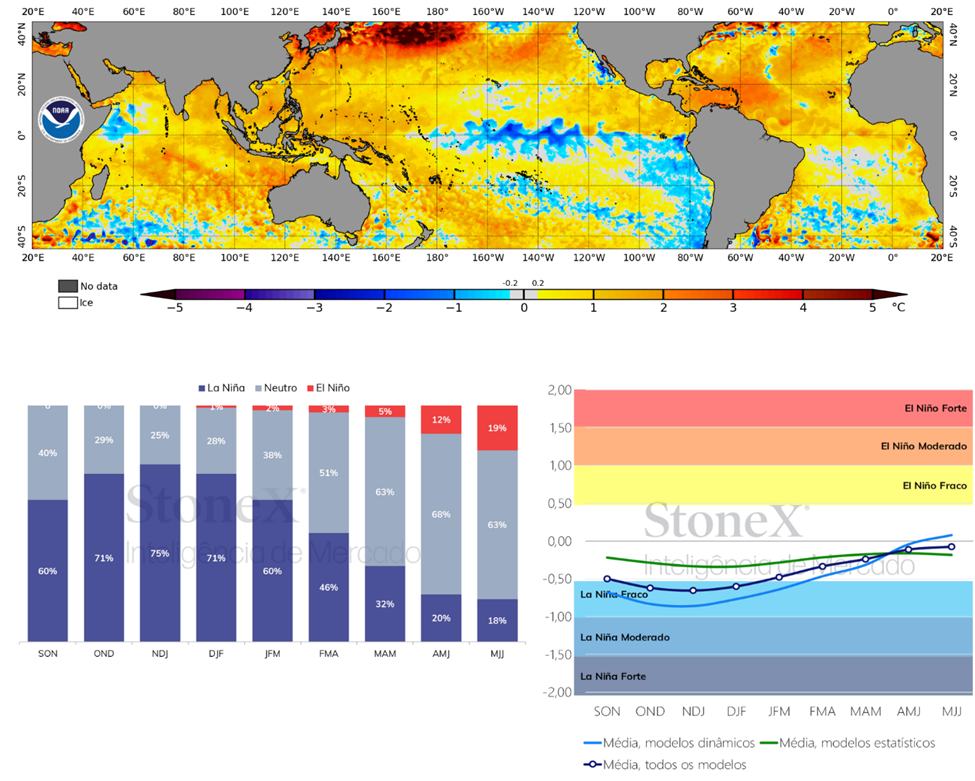
Ocean surface temperature anomaly recorded on October 13, 2024 from NOAA (A), the official ENOS probability forecast from the CPC (B) and the intensity of the phenomenon (C), based on a consensus of meteorologists from the CPC and IRI.
Sources: NOOA, IRI. Design: StoneX.
El Niño-Southern Oscillation (ENSO) refers to two interconnected phenomena. El Niño deals with changes in the surface temperature of the Pacific Ocean, while the Southern Oscillation refers to simultaneous variations in atmospheric pressure. ENSO alters global weather patterns.
In simpler terms, under normal conditions, the waters of the Pacific Ocean in the region near South America are colder, while the waters near Australia and Indonesia are warmer. This is because the winds blow from east to west, pushing the warm waters towards Australia and leaving room for the cold waters to rise to the surface (upwelling) near the coast of South America.
The El Niño phenomenon occurs when the winds which normally blow from east to west weaken. This causes the waters of the Pacific Ocean in the region close to South America to become warmer than normal. As a result, less cold water rises to the surface near the coast of South America.
The La Niña phenomenon occurs when the winds become stronger, causing the waters of the Pacific Ocean near South America to become even colder. This cooling happens because more cold water rises to the surface in this region, due to the strengthening of the winds. The best way to understand La Niña is to think of a more intense version of the neutral conditions for most regions.
On October 10, the IRI confirmed La Niña with a 75% chance of gaining strength during the November, December and January (NDJ) quarter, ending the neutral phase. The likelihood is that the phenomenon will be short-lived, with a 63% chance of a return to neutral conditions from the March, April and May quarter of 2025. In the months of November and December, the intensity of the phenomenon could reach a TSM anomaly of -1°C, which is considered low. The phenomenon can substantially intensify moisture currents from the tropics and increase the number of cloudy days, as well as the frequency, duration and intensity of rainfall related to extreme events that trigger landslides and water erosion.
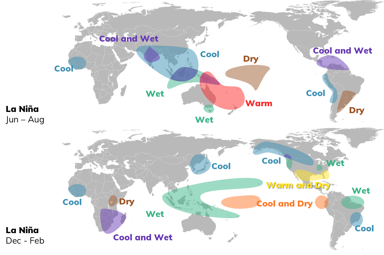
Possible impacts of ENSO in Brazil
Source: NOAA. Design: StoneX.
In Brazil, generally when La Niña appears at the end of the year, it has been observed, although it is not yet considered a pattern, that the Southeast and part of the Center-West become colder. The north becomes wetter and southern Brazil drier. In recent years, both El Niño and La Niña have been more intense and longer-lasting, compared to the neutral phase, associated with a more stable climate.
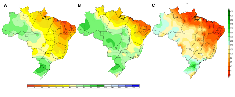
Accumulated precipitation over 10 days expected for the second and third 10-day periods of October (A, B), and the forecast for total precipitation expected for the month (C).
Source: Inmet.
Towards the end of October and November, episodes of the South Atlantic Convergence Zone (SACZ) will bring widespread rainfall to the Southeast, Midwest, Acre and Rondônia. Climatologically, this is a transition period between the dry and rainy seasons in Central Brazil. As it is a transition, it is expected that in the last 10 days (approximately after October 20) the rains will become more regular throughout central Brazil, with significant volumes, over 50 mm in 10 days, in parts of the North, Midwest and the state of Tocantins. It is therefore likely that the month will end with above-average volumes of rain (generally above 100 mm) throughout the Center-West, parts of the Southeast, North and Northeast, with volumes exceeding 30 mm. In southern Brazil, on the coast of the state of São Paulo, in the north of the state of Amazonas, Acre and Rondônia, volumes could exceed 130 mm.
Cumulative rainfall forecast (mm) for the month of October: A) Oct. 15 - Oct. 19, B) Oct. 20 - Oct. 24 and C) Oct. 25 - Oct. 29
Data from the GFSv2 model (right) ECMWF (left) and run on October 15, 2024.
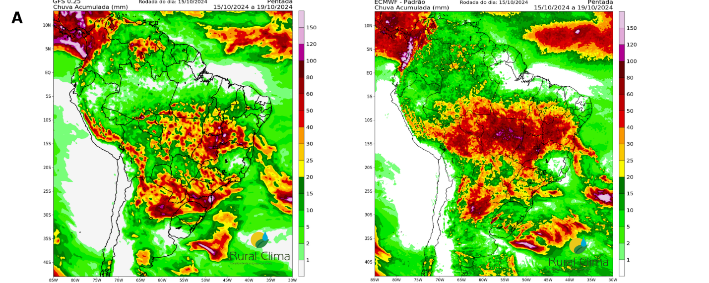
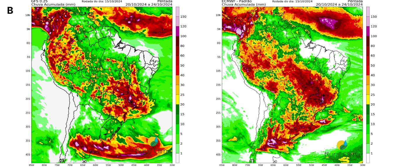
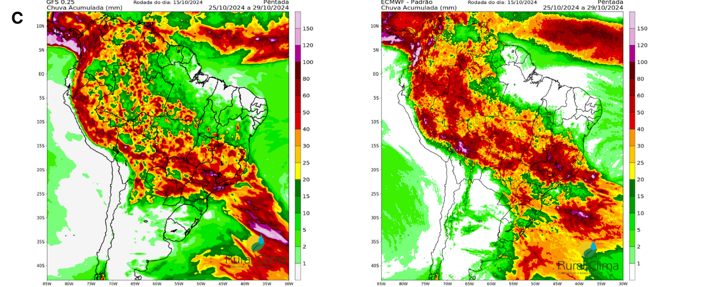
Source: Rural Clima.
The GFS/CFS (United States) and ECMWF (European) rainfall prediction models after October 15 jointly point to widespread moisture throughout Brazil without long dry spells (more than 10 days without significant rain). The European model signals higher volumes, concentrated in central Brazil, but for the Northeast region after October 20 it signals a period of drought until the end of the month. On the other hand, the American model predicts lower volumes, but moisture spread across Brazil as far as the northeast.
Maximum temperature forecast from October 15 (A) to October 26 (L)
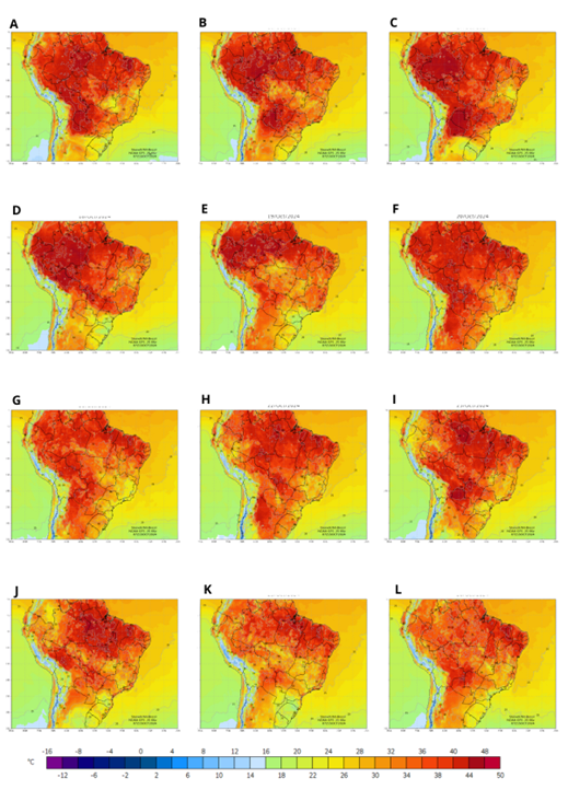
Source: StoneX.
According to the American model, starting from October 16th, maximum temperatures are expected to drop significantly due to increased cloud cover, especially in the Southeast regions and the state of Goiás. This will substantially reduce the occurrence of temperatures above 40 degrees Celsius, which had been recorded for several consecutive days.
The weather conditions and the seasonal forecast indicate a favorable scenario for most perennial crops, as well as for planting schedules and the development of short-cycle crops in this first crop after an intense drought. For the coffee fruits that have formed and remained, either because the crops had irrigation systems or because they were in the zero crop phase, the forecast conditions may be better for the crop's development.